Saturday, May 5, 2018

Esther 4-22-2018

Hanging at the Summit of Marble Mountain.


Hiking Giant in late August of last year,  Kailee met a bunch of kids on the trail that told her they were working on becoming 46ers. I can confirm that they all listed the same four mountains to their credit (Cascade, Porter, Big Slide & Giant).

Kailee proudly replied that "This (Giant) is my first one."

Kails checked off  Porter & Cascade soon enough.

Around this time, PBS ran a big ad campaign for the 46ers Film... Kailee decided, quite quickly, that she too wanted to be a 46er.

My job is to get her on a good start.


Kailee leading the charge!
The top thing on her list for 8 months has been Whiteface & Esther... There's a CASTLE on Whiteface & she wants to go inside.

It's possibly the most popular Mountain in NY & we've seen it from almost every summit & angle that we've come across.

The Mean Mile up Marble.
I decided that it could be fun to climb to Marble Mountain -a minor summit on the Whiteface massif- and hike a little more of the trail upwards towards the 'Face to scout things out for a potential climb later this year.

We parked the car at the Scientific Atmospheric Research Center and strapped on our gear under beautiful blue skies.

There was no register. Just a bench with a little sign that indicated "Trail." The trail leads you around to the back of the Research Center to the base of the mountain. There's a snowmobile trail or two that runs through this area but it's easy to spot the hiking trail to Marble. It's the one that goes straight up.

An old Ski Patrol supply shelter on Marble.
The path up Marble follows an old ski resort tow-rope route & it has an unforgiving incline. The main highlights of this stretch of trail was passing an old Ski Patrol supply shelter and getting a few views through the leafless trees when we turned around.

That being said, Marble's lookout near it's Summit was the perfect place for lunch.

A view from Marble.
After lunch, we headed up the trail towards Lookout Mountain to check things out. It didn't take very long for things to ease up... A welcomed relief!

Lookout Mountain is a 4000' peak that lacks the prominence required to be considered a true peak. Because of this, it is not regarded as one of New York's High Peaks.  Like Marble, Lookout is just a small bump on the massif.

I took a short video.


"We're heading up Lookout Mountain now. We're gonna see how far we go. We're not on a big, big summit day. We're just checking out the trails a little. Then we'll turn around."

I underestimated things.

"Hey, we're now higher than I was on Ampersand," I said after checking the GPS.

"Woah," Kailee replied.

A little further more, I checked the GPS.

"We're now higher than we were on Noonmark," I declared.

"Woah. Really?" Kails replied.

We were nearing the top of Lookout when we met a Quebecouis woman who was on her descent. She was shocked to see a girl of Kailee's age at such a location.

We simply expressed to her that Kailee is Seven & "She likes to climb the big ones."

Which drew a moment of awe from the woman.

Our pace & the pure luck of perfect "late Winter" of conditions allowed us to get to the Lookout trail-split for Esther.


"We're not too far from Esther," I said,  "I think we can grab it!"

"I don't know... You said that we could go back at any time..." Kailee replied.

"I think we have the Sunlight and it might be easier to go over there now... Rather than in the Summertime," I stated, "We won't have to deal with mud or bugs. If it starts to look too hard or the Sun starts setting too quickly. Then, we'll turn around!"

"OK!" Kailee enthusiastically replied.

Herd Path!
The walk to Esther's Summit ended up being a breeze. Just follow the footsteps in the snow.
At a few points, I lifted Kailee up to expand her view of Whiteface.

Whiteface

"This is awesome!" she shouted looking at her favorite unclimbed peak.

A number of hikers passed us on their way down.

Our excitement grew as we neared the Summit of Esther. The fact that we were on an "Unmarked, un-maintained trail" with amazing views of the 'Face added to Kailee's emotions.

I let her lead to Esther's Summit.

"Good job!" yelled Kailee.

"Good job Kailee!" I replied.


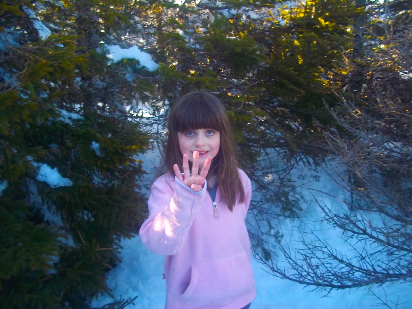
"Fourth Forter-Sixer!" Kailee shouted as she made a four signal with her hand.

"This is her fourth 46-er!" I exclaimed.


It was amazing. We slapped a high five at 4240' above sea-level and explored Esther's Summit.

I've read that Esther isn't known for it's views. I'm no giant. I'm 6' and standing on 2-3' of snow looking over the stunted pines offered me a fine view of the Green Mountains, Lake Champlain and the Great Range.

Who says Esther doesn't have a view!?!

After some water and exploration, we began our hike out.

One of the humorous moments during our descent was on Lookout when I realized that one of the tiny peaks a few miles away from us was our friend Clark!

It was quicker & easier to descend Marble Mountain. But, yet again, it was the most wearing part of the hike.


We were back at the car 90 minutes after leaving the Summit with plenty sunlight to spare. We slapped another high five and quickly changed out of our boots and socks.

We hadn't planned on hiking that far or high. The exhilaration upon summiting Esther followed both of us in the ensuing days... I'm still feeling the reverberations from it.

"Wow, I can't believe we did that!"


Friday, April 13, 2018

Split Rock Mountain Wild Forest (3-25-2018)


We recently took a trip to Split Rock Mountain & Wild Forest on the shores of Lake Champlain.

I was pretty sick the last few weeks of Winter and missed out on some end of  season hikes as a result. 

Split Rock is fairly close to home. It offered us an Adirondack experience without too much exertion... I couldn't complain.

Remains of a bed.

Split Rock has a trove of trails for hikers, skiers, snowmobilers & campers alike. And, from the looks of it, they follow old logging roads. We passed the remains of some old cabins and an old metal bed headboard that someone had leaned up against a tree. I always like finding that sort of stuff while hiking.

The trails lead to a series of lookouts and actually just skirt the Summit. My plan was for us to make a short bushwhack to it.

At one lookout, Kailee pulled out a "Happy Birthday" poster that she made for my brother. She posed for a picture at an overlook with the Boquet Valley, Split Rock Wildway, and the High Peaks behind her.

Kailee with a special poster that she made.

I glanced at the GPS quickly and figured this was the approximate area to start our bushwhack to the top.

It was a quick and easy little climb and we followed deer tracks on our way up. We hit a spot that offered a great view of Lake Champlain to the South and the Adirondacks to the West. We walked to the highest point and could see Mount Mansfield, Camel's Hump and the Green Mountains through the trees to the East.

Looking towards Southern Lake Champlain.

Then I noticed that I had undershot our destination and that we were standing atop a false summit. The real Summit was maybe 20 feet higher, less than 2/10ths of a mile away with a small col separating us.

We had both gotten socked by some unseen runoff under the snow shortly before reaching the false summit. Kailee had backup socks in her backpack. My extras were accidentally left in the car.

"I'm having fun. But, I think we should head back to the car," Kailee said.

"I was just thinking the same thing," I replied.


Looking Northwest.

We ended up hiking 4.6 miles total... which is probably only a fraction of the trails at Split Rock Mountain. This is a place that I would like to do some further exploring. From everything I experienced, it seemed like Split Rock is a great place for novice and experienced hikers. Kailee gives it two thumbs up!


Monday, March 5, 2018

South Boquet Mountain (2-26-2018)


This has been the warmest February that I can remember in ages. I was hoping to get out and hike with Kailee on Sunday but we stayed inside because of rain and sleet. However, the weather for Monday looked extremely promising. I figured I could get a quick hike in while she was at school.

So, I turned to the Champlain Area Trails website and decided to check out the Wildway Overlook Trail on South Boquet Mountain.

I was surprised to see two trooper cars
at the trailhead.


As I pulled up to the parking area, there were two State Trooper cars parked with their lights on. No one was in the vehicles. So, I waited a few minutes for the officers to return. They came out of the woods on the other side of the street and assured me that I was good to go for my hike. It turns out, the troopers had responded to a call for a supposed trespasser.


I signed in at the trail register as the troopers took off.

Much like Cheney Mountain (also maintained by CATS), South Boquet  Mountain was once used for logging. You follow an old jeep road through a young birch forest. There's a number of information panels along the trail that offer insight to the local habitat.

Looking back through the trees on the trail.
The Wildway Overlook Trail has no obstacles to overcome and the grade is pretty easy. It leads you to the mountain's southern summit which offers a wonderful view of the Lake Champlain, the valley, Split Rock Mountain and Vermont's Camel's Hump.

I took a few minutes and sat on a memorial bench and enjoyed the view. This would make an excellent picnic spot!

At the Lookout.
I took a quick trip on a herd path to the North (true) Summit just to be a perfectionist before returning to the Overlook.


View from the Wildway Lookout on South Boquet Mountain.

I decided this might be a fun chance to bushwhack down the hill
(Always use GPS or map and compass when whacking!).

It was an enjoyable and easy descent through the woods. I kept running into different logging roads and would follow them for a bit before cutting back into the woods.

Giant Mountain through the trees -
bushwhacking South Boquet Mountain.

Through the thin trees, Giant Mountain and it's massive white slides were visible. Eventually, I popped back out on the trail right at the register. I checked myself out and headed home.

The Wildway Overlook Trail at South Boquet Mountain is a great trail for almost everyone. Sticking to the trail, it's two miles out and back with approximately 600' of elevation gain. The view is far greater than the effort invested to climb this one.

The Wildway Overlook Trail is located on Brookfield Road in Whallonsburg.
Visit the CATS website for more information on their network of trails.

Mountain Math: South Boquet Mountain is the shortest mountain that I've climbed in the past year at only 1,233'. In terms of height, it's ranked 1,860th in the state. However, it's other stats are staggering for such a small peak. Due to it's excellent isolation and rise, South Boquet is ranked 297th in prominence in New York! 


Tuesday, February 20, 2018

Rattlesnake - Poke-O-Moonshine - St. Regis (2/18 & 2/19/2018)


St. Regis! YES!

Kailee was visiting my parents in Albany for Winter break. That left me with some free time on my days off. We've had a bit of a warm streak lately in the North Country. So, I figured "might as well get some Winter hikes in."

For full disclosure, I'm new to hiking mountains in the Winter and have been sticking to trails that I'm familiar with. I guess you could say "A new season of Learning the Trails!"

Rattlesnake - 2/18/2018

Rattlesnake's Summit.

The Snake is a pretty easy hike in Willsboro that offers wonderful views of Lake Champlain, Willsboro Point, Four Brothers Islands & Vermont's Green Mountains. 

The Four Brothers and part of
Willsboro Point from the Snake.
Like many mountains in New York's Champlain Valley, it lacks the elevation of it's Adirondack counterparts. But, it's views easily make up for that.

I hit the trail around 3PM on Sunday. About 100 feet in, I noticed the remains of a dead turkey... That wouldn't be the first time on this day... Some critter was out there picking off a bunch of belated Thanksgiving dinners.

The first of numerous turkey remains...

I moved at a pleasant pace, the trail was well broken and it didn't take too long to reach the Summit. 

Once there, I took in the views, shed my fleece underlayer, and refueled with water.

I quickly got the idea to tack on Poke-O-Moonshine for a second hike of the day.
For the heck of it, I bushwhacked around the Snake's crag for an easy descent back to the trail and my car.

The Sun breaking through the clouds and illuminating Giant 
from Rattlesnake.

I hopped in and drove to nearby Poke-O-Moonshine.


Another dead turkey on Rattlesnake.

Poke-O-Moonshine 2/18/2018

I could see a number of ice climbers working their way up Poke-O's ice wall as I pulled into the parking lot. They were pretty far up the face. That type of climb isn't for me... I hit the Ranger Trail.

I was feeling good after the Snake and made my way to the first lookout in no time.

Then... It got tough.

Too many layers of clothes, ice, dehydration and frosty elevation gain were a few of the factors working against me.

Yeah... That ice is the trail.
It felt like I was making really slow progress after the first lookout. I was getting tired... Physically and mentally.


I psyched myself out. However, once I hit the remains of the old Observer's Cabin, I felt a sigh of relief. Since I was clearly the only person left on the trail, I ditched my pack and took only my camera, headlamp, GPS and cell phone with me on my procession to the Summit.

Ditching the gear was a welcome reprieve. I briskly made my way to the fire tower/Summit and checked out the views on the ledge.

Poke-O-Moonshine... Definetely no time to 
climb the tower!
Sunset hit just as I summited. I snapped a few pictures, strapped on my headlamp and immediately made my descent.

Gettin' dark...

I made my way through the dark without incident. 

I was quite drained when I reached my car. I needed more liquids. I was hot. I was getting hungry. My legs ached. I was glad when I got home and was able to tend to each of these issues.

Poke-O Tower.

St. Regis Mountain 2/19/2018


St. Regis Mountain's Fire Tower.

My legs were beat when I woke up. But, I was determined to have the best hike possible as I prepared to tackle St. Regis.

Orange ice!

I packed as lightly as one could without forgoing any of the essentials. The weather was forecasted to be in the mid-40s for Santa Clara, NY. So, I opted to use my camelback instead of clunky water bottles.

That's... Erratic..
I had been debating on doing Scarface or St. Regis for Monday. 
A facebook friend climbed St. Reeg on Saturday and reported that microspikes were all that were needed for the climb. Perfect!


And, that was pretty much how it went... Perfectly!

Did my legs hurt from My adventures at Rattlesnake and Poke-O?
Yes.

Did I let that bother me? 
No.

I maintained a good pace and enjoyed every minute of the hike.

It felt like I was making quicker progress than Sean and I had in the dog days of July.
A whole new snow covered world was ahead of me... Checking the mountain out in a Winter setting was awesome.


It felt awesome too.

The last 3/10th's of a mile is where the climb really kicks in. But, I was feeling positive and had made decent time to up until that point. So, I kinda lolligagged my way up the brief final stretch to save my tired legs the hassle.

Hanging at St. Regis!
In my opinion, St. Regis Mountain has one of the finest summits for a mid-sized mountain. And, upon reaching it, I was greeted with some screaming wind which I had been protected from while on the trail.

The view at St. Regis.

I didn't climb the fire tower to enhance my view because of the blasts of wind. Rather, I hid behind trees until breaks allowed me to walk around and take things in.


More St. Regis views.

I spent less time on the Summit than planned. That was fine. I had been itching for a good hike with decent distance and elevation gain and got it!


Kailee's Eevee doll accompanied me
on the hike at St. Regis Mountain.

I felt reinvigorated on my descent and was happy with knocking out three Summits in less than 24 hours... The good. The bad. The ups... The ups... The ups... And the downs.. All of it.
Time well spent!


GPS Stats:
In less than 24 hours, I climbed Rattlesnake, Poke-O-Moonshine & St. Regis Mountains.

Miles:
12.6 miles

Elevation Gain:
4019 feet


Sunday, February 18, 2018

Conner's Bay - Rams Head Trail - 2-12-2018

Looking across frozen Lake Champlain at Vermont from
the Conner's Bay trail. This photo was taken by
Kailee.
A guy at work recently suggested that Kailee and I check out the Ram's Head Trail at Point Au Roche. We took his advice and walked parts of that & the Conner's Bay trail on a beautiful Winter evening.

We started by the Nature Center at the park and followed the Bay Trail over an easy grade.

Mt Mansfield has a very Alpine appearance in the Winter.

As we neared Ram's Head, we went off trail and walked across the frozen bay. Ram's Head (a peninsula that looks like it's namesake) has a nice look out spot. We walked around the Head and decided to follow (and not step on) a cross country skier's tracks on the lake back to our starting point.


Looking towards the Adirondacks. I can see a few
mountains that we've climbed!

The trails offered nice views of Mt Mansfield, Camel's Hump & the Green Mountains of Vermont. Ram's Head itself gave us pleasant views of Poke-O-Moonshine, Whiteface and many of the Adirondacks.

Looking up at the Conner's Bay Trail from Lake Champlain.


The sky put on a nice display of colors during our 2.3 mile walk. Both trails are suitable for year round hikes!

Colors Abound!


Deep Purple back at Deep Bay.

Tuesday, February 13, 2018

SLM - 2-5-18 (Solo)


This was the third time that I've climbed Silver Lake Mountain in as many seasons.


As I said in one of my recent posts... SLM is a good practice mountain & it's close to home... I won't drag you down with a long post with this time... But, I will say, it was a windy day with absolutely perfect bluebird skies!

Potter Massif.
It was a nice walk to the top of SLM. I did some bushwhacking (again) on my way down.


To get this view, you have to go just a little bit off trail.


I stumbled upon a really "cool" crystal cave of ice & rock while 
hiking off-trail on my way down SLM.

A quick, pleasant trip in the ADK while Kailee was at school!