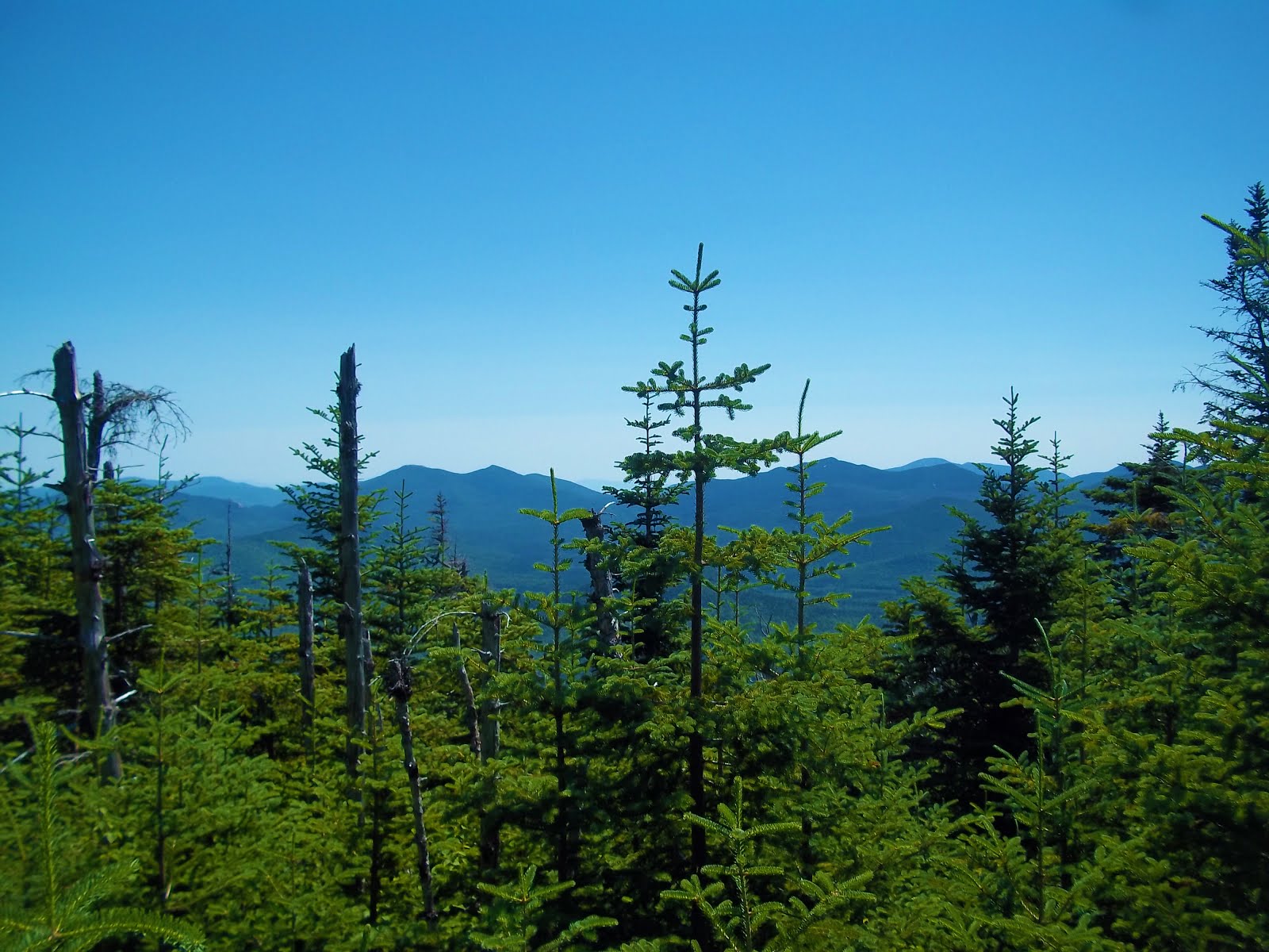
Tuesday, July 31, 2018

Macomb, South Dix & Hough (7-16-2018)

South Dix


Camp Out

Kailee and I spent a relaxing Sunday at Sharp Bridge Campground in North Hudson. It's a sleepy little campground that happens to be one of our favorite places in the world. Sharp Bridge is close to a bunch of great trails and also hosts it's own impressive trail to the East Mill Flow and Round Pond (not to be confused with Round Pond on Route 73). There's also a side trail that leads up to Sharp Bridge cliffs.


Sharp Bridge.

We went up to the cliffs shortly after setting up camp. I noticed some recent blowdown opened up the view a little more towards the Dix Range. This was a nice view of of Macomb - the High Peak we'd be attempting to climb the following day.


Sunset at Sharp Bridge Cliffs.
Looking towards Dix.


I enjoyed relaxing as Kailee had fun fishing in the Schroon River. After that, we walked up the road to visit Courtney Pond to see if we could find a few water snakes. We spotted two.

At the end of the day, we watched the sunset back at Sharp Bridge Cliffs.

The Hike

We awoke at 6AM on Monday, broke down camp, used the bathrooms and set off for the Elk Lake trailhead parking lot. It was a quick ride. It's a small lot & it fills up quickly... Getting there early is a must.

With a parking spot secured, we took our time to get our stuff together. Then we signed the register & set out for Macomb!

We followed the Hunter's Pass trail towards the Slide Brook Lean-to. This trail is mostly flat, fairly wide and crosses a few small streams. Around halfway to Slide Brook we noticed a benchmark on a large rock in the middle of the trail.


Benchmark on Hunter's Pass Trail.


There was a bridge over a stream that recently succumbed to the forces of nature at the 2 mile mark. We rock hopped across the stream & spotted the Slide Brook camp. We had no trouble finding the cairn that led us to the unmarked trail up Macomb.

The trail gained elevation pretty quickly as we walked through the trees. Then we popped out at Macomb's "new" slide.

"So, we're climbing a slide?" Kailee asked.

"Yeah, I forgot to tell you that," I replied.


Blinding Sun over Macomb's Slide.

Macomb's slide is listed as the fourth steepest established route in the Adirondacks. It's comprised of sand and rubble. I thought it wasn't overly intimidating and it was a pretty short slide climb in comparison to Bennies Brook Slide. We practiced careful footing while ascending & tried to avoid kicking free any rocks.

Around halfway up, two guys reached the bottom of the slide and began their climb.

Turning around on the slide offered some really nice views of Elk Lake. At the top of the slide there was a cairn to the left indicating the path to the summit.


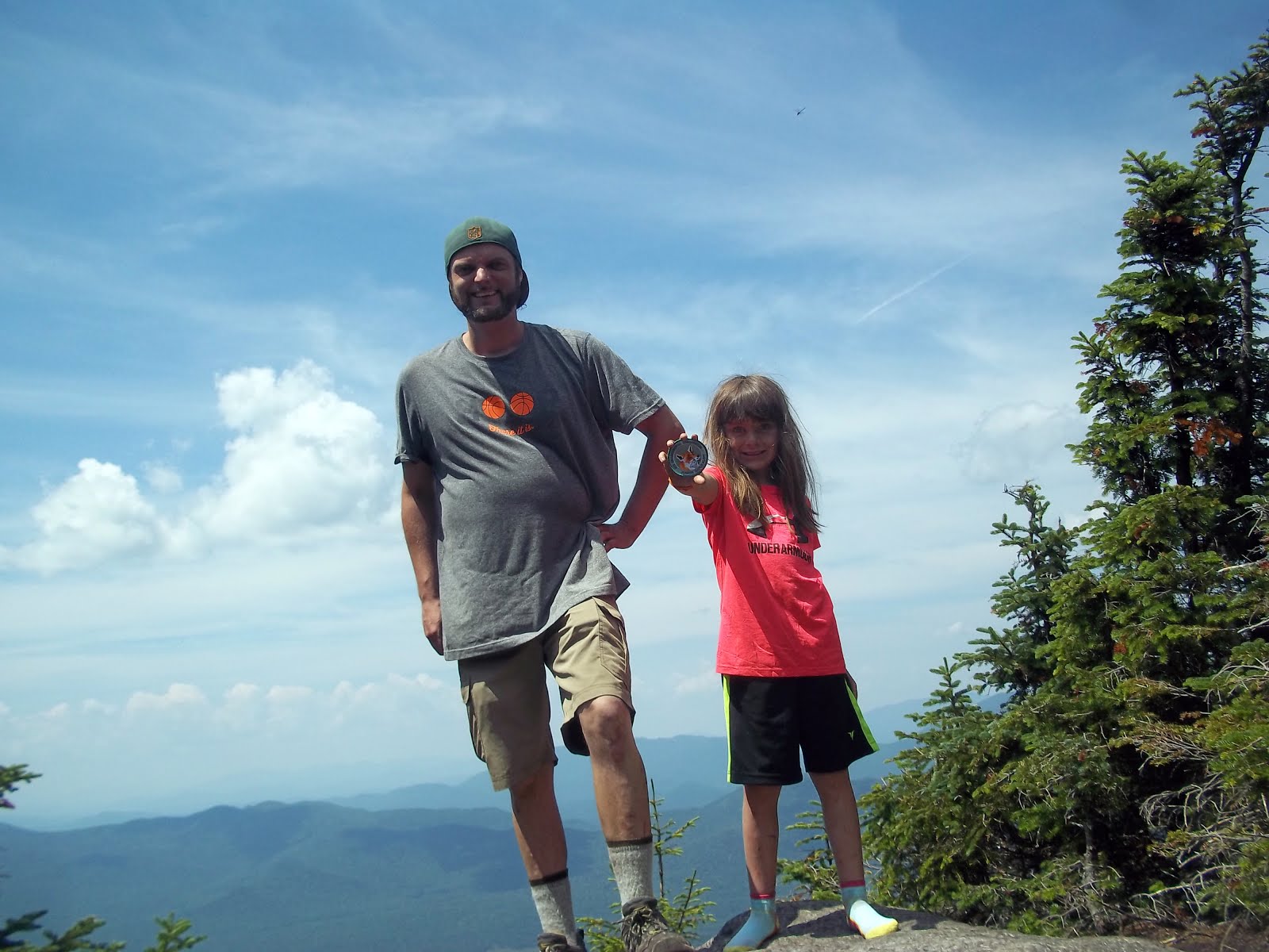
Macomb! Our 11th High Peak.
Kailee with her Junior Naturalist badge that she earned
at Sharp Bridge.


It was a short climb from this point to the Summit and only involved an easy scramble or two.  Kailee and I arrived at the summit in 3 hours and 50 minutes. Not too bad! This was our 11th High Peak and we were pretty excited.

The two Bros from below caught up to us.

"Is this Make-Em?" the one bro asked.

"Yeah, it's Macomb," I replied... I think he only heard me say "Yeah."

He and his pal were friendly and we chatted it up with them while enjoying the view on top of Macomb. They were planning on climbing all five peaks in the Dix Range & soon departed.


View from Macomb.

Another guy arrived at Macomb a few minutes after they left. He was just finishing up a hike of the whole range. This hiker and the two bros would be the only people we saw for the rest of the day. We spent 40 minutes atop Macomb before heading out.


Photogenic Tiger Swallowtail.


Kailee didn't want to descend the slide. So we took the range trail down. We hit a junction. Left would take us to the Lillian Brook exit path and right would take us to South Dix. Looking at South Dix, we made the in game decision to add it to our hike.


South Dix scramble.
Scramble and Dance on the way up South Dix.


It was maybe a 200 foot scramble on open rock from the ridge to the top of South Dix. Despite the heat, this was a lot of fun! And, the views from South Dix were quite impressive!

Our 12th High Peak: Check it off the list!


South Dix.
High Peak #12!


We departed South Dix after taking in the scenery and descended Northbound on the Range Trail. We evidently went up and over "Pough" (pronounced "Puff") but I hardly noticed that we were on a "sub-peak."


View from South Dix.

We came to a junction where a path to the East led to the Lillian Brook Trail & the Range Trail continued North to Hough... We made another in game decision to add Hough to our hike. It looked really close and my GPS confirmed it was only a short distance away.

Since we would be returning to this spot, I hid my backpack and carried Kailee's (much smaller) pack up Hough.

Compared to Macomb's Slide & South Dix's open scramble, the Range Trail up Hough felt like the most "normal" stretch of trail we had been on all day. It did have one (optional) scramble up a rock outcropping that had a nice view. I shouted "Hello" and my echo rang out for almost a good minute!

From the outcrop, it was only a few minutes until we were on our third summit of the day and 13th overall High Peak! We arrived at Hough at 2:45 PM.


Hough! Our 13th High Peak!

We were pleased and proud to be standing atop our third peak of the day when we had only set out to climb one. The view of Dix, the High Peaks & Elk Lake were a wonderful reward for such an an exciting & spontaneous outing!


Dix from Hough.

We spent around 15 minutes at Hough before descending back down to the col. At the col we ran into the Bros again and gave them a fist bump!

"You guys continued on after Make-Em, eh?" asked Bro #1.

I corrected him again and informed him that it was pronounced "Ma - Comb." This time he heard me.

"How was Hough?" Bro #2 asked.

"It's really nice," I replied "Have fun with that drop between it and Dix."

"Oh, it's really steep?" Bro #2 asked.

"Looked that way to me," I replied "Have fun."


View from Hough.

After they left, we took a snack break in the trail junction clearing. Kailee called my Mom to inform her of our accomplishment.

Then we began descending on the Lillian Brook trail. I had run out of water before ascending Hough and was looking forward to getting to the brook and refilling.

We were moving at a really good pace... And, then the trail disappeared.

We were surrounded by a warzone of blowdown. I looked for signs of a workaround and even backtracked to see if we missed a turn. All of the little paths that I found were dead ends...

I decided to plug the brooks coordinates into the GPS and bushwhack us to the stream.

This ended up being the most demanding stretch of the day. Bushwhacking in the hottest part of the afternoon crippled our brisk pace. The whack required more energy and time. I began to sweat like I've never sweat before. All of these factors resulted in me becoming extremely dehydrated very quickly.

I went from being in a great mood to completely miserable in no time. Kailee on the other hand was well hydrated, still had water and was in good spirits.

I felt like a zombie when we arrived at the stream. I tried to relax while filtering water. I was relieved to be at a water source but still physically and mentally miserable.

Kailee broke me out of this trance by cracking some jokes and saying stuff like "This has really been one of my favorite hikes. This has been really fun."
I needed to hear this. It snapped me out of my misery & helped get my mood back on track.


Thankfully, the trail was right on the shore of the brook and we were able to follow it to the bottom. We took another break when we reached the Hunter's Pass trail. Then, we began the trek back to the parking lot.


Shroom on the Lillian Brook Trail.

There were now a bunch of hikers camped out at the Slide Brook sites. We continued on and took two more breaks on our way to the parking.

Arriving at the car was an incredible relief for me. I couldn't wait to crack one of the sodas that I had stashed in my vehicle & passed a Gatorade to Kailee.


This was a much longer day than planned. Our bushwhack made it an even longer day. I personally went through quite a spectrum of emotions. But, that's what a hike is about.

The positives far outweighed the negatives. Going from peak-to-peak-to-peak in a quick succession on the Range Trail was a huge highlight for both of us. It was so much fun and the nonstop views were incredible.

Kailee was extremely proud that to have grabbed her 11th, 12th and 13th High Peaks in such a short amount of time! And, she's spot on with her assessment "That was a great hike."


"A great hike."


Nye & Street 7-9-2018


Nye Mountain.

Our adventures in the High Peaks have been a lot of fun. We were looking to break into the double digits with a climb of Nye & Street in Lake Placid.

We arrived at the Adirondack Loj at 7:15am on a Monday. It's known that the Loj parking lot fills up quickly. But, there were very few cars there on this day.

Nye & Street have an unmarked trail. The parking attendant gave us a little run down of of things to look for on our hike and get us where we wanted to go.

Since this was our first visit to the Loj, we checked out the High Peaks Info Center before setting off on our hike. It's a cool little building with a gift shop and a small cafe.

It was nice change from getting out of the car and immediately starting a hike. After browsing around for a bit we went back to the car and strapped on our gear.


Reflection of Street on Heart Lake.

The trail to Nye & Street follows the Heart Lake Loop & trail to Mount Jo for a stretch. Heart Lake is a spectacular sight. Street and the MacIntyres reflection shimmered on the calm water.
We passed a very tiny Adirondack museum & garden. Something to check out more on a future visit.


We arrived at a sign reminding us that the Old Nye Ski trail is unmarked & unmaintained. We followed it down to Indian Brook. There's a bunch of herd paths that lead down to the brook. We stayed on the main trail until I spotted the cairn across the brook. We then picked a good place to rock hop and made our way to the cairn.


Time to rock hop!


The old ski trail follows a runoff & there was a few muddy spots. Nothing bad.

Eventually, we came to a clearing. This would make a good spot for a snack or lunch.  A tree had "Nye & ST" carved into it with arrows pointing the way to each.


Trail Junction.

Right led to Nye & we went there first. It only took a few minutes from the junction to the summit of Nye. This way our Ninth High Peak (or Nye-nth... Get it!?!)

Nye is tree-d in, but Kailee found a little herd path which led to a small view point. This spot doesn't offer a sweeping vista but I enjoyed the view. Nye is one of the few High Peaks that falls under 4000'. So, a view like this was evidence of a healthy ecosystem for a peak of such stature.


View from Nye

We ate a quick lunch at the Summit and backtracked towards the col. We checked out a very tiny rock outcrop that gave us another little view of Street & the Macs.

Once back at the junction, we set our sites on our tenth High Peak: Street. The trail meanders through the trees on the way towards the summit. It was a very easy & relaxing climb.
Summit of Street.

Street's summit also offers no views. But, just past it there is a nice lookout that offers a great view of Algonquin to the Southeast, the Sewards to the West and Ampersand in the North. A plethora of smaller peaks decorated the beautiful background.


Street's overlook. 


I really liked the view point on Street. It feels like your standing in an audience of thousands of small pines.


Looking Northwest.

It was pretty hot, so eating a second lunch at the summit seemed like a good idea before we made our descent.

We were afforded a few bonus peeps as we walked down the trail.

Once we got back to the Loj, I asked Kailee if she wanted to take a quick dip in Heart Lake.

She excitedly yelled "Yes!" and ran into the water.

This was a fun way to celebrate breaking into the double digits!


Sunday, July 22, 2018

Fireworks Everywhere! Poke-O-Moonshine 7-4-2018


A few days before the Fourth of July, it dawned on me that it could be fun to do a  Poke-O-Moonshine sunset hike and watch all of the firework displays up and down the Champlain Valley.

This idea reminded me of something my friends and I did when we were a little younger. We drove up the Helderberg Mountains to Thatcher Park and watched the fireworks all over the Capital District. 


I worked on the holiday this year. After finishing up, I made the quick drive to Poke-O and climbed it at the perfect time!

The Friends of Poke-O-Moonshine have
been working vigorously on the mountain
and trail. As of two months ago,
this was a dilapidated cabin. Now, only
the foundation remains.


I made it to the top approximately 20 minutes before the major shows began in Plattsburgh & Burlington (their shows began at 9:30PM).


I didn't bother taking any pictures of the fireworks because my camera is terrible at that sort of thing.
But, it was certainly pretty cool to watch every firework set off within 100 miles.
The sunset to the West over Whiteface was great as well!

Wednesday, July 4, 2018

Bennies Brook Slide - Lower Wolfjaw - Upper Wolfjaw 6/25/2018

Bennies Brook Slide.


Disclaimer: Slide climbing is inherently more dangerous than taking a common trail. Everything that can go wrong on a "normal" trail is quantified by an incredible margin during a slide climb. 
If the weather wants to beat you down... It will. 
If a rock wants to roll... it will roll. 
If the weather wants to beat you down at the same time that a rock decides to roll -Best of luck to you.

Many other things can go wrong during a slide climb. DON'T sit there and think "Well the guy on the internet did it. My kids and I can do it too!"  The author and his daughter hiked hundreds of miles in the Adirondacks before attempting this climb. If you have minimal experience hiking in the ADK , DO NOT let Kailee's age deceive you...  DO NOT attempt this climb until you've gotten some real open rock climbs and serious experience under your belt. Know Your limitations & use your better judgment!!!    


Lower Woljaw & Bennies Brook Slide (Left-Center). Upper Wolfjaw
(Right-Center) from Big Slide Mountain.

Kailee & I have wanted to get a taste of the Great Range for a while. It's something that we've been hoping to sink our teeth in to...  I figured that we could take a bite out of it by climbing Lower Wolfjaw Mountain - the High Peak in the range nearest to civilization.

There's a few trails that one can take up Lower Wolfjaw. I was leaning towards the Roostercomb-Hedgehog route. But, I was also considering the trail out of the AMR.

I decided to message my friend Sam. He's a super experienced Adirondack 46er and all around explorer.

Me: Hey, which is less of a grind to Lower Wolfjaw: Roostercomb or AMR?

Sam: The only enjoyable way up LWJ is Bennies Brook Slide

Me: I freaking knew you were gonna say that
!

I was aware of Bennies Brook Slide. My friend Jim and I had complimented it's dominating appearance on our recent hike at Big Slide Mountain...

It's the real deal.


Varied terrain on Bennies Brook Slide
on Lower Wolfjaw Mountain.

Sam: How did she do on Catamount?

Me: Fine.

Sam: Then she'll have no problem with Bennies.


Sam provided me with a ton of extremely beneficial resources to help Kailee & I on our first attempt at a full slide climb. His assistance was invaluable to pulling off this climb.

Kailee and I arrived at the Garden pretty early. After signing in at the trail register, we set out to Learn the Slide.


Garden Register.


We followed the Phelps Trail for the first leg of our approach. This was the same trail that we took on our exit from Big Slide two weeks prior.

Near the two mile mark, we took a left off of the trail and bushwhacked down to Johns Brook. I had studied a number of maps and other trip reports & determined this shortcut could save us some mileage.


Johns Brook.


By total chance of luck, we popped out of the woods and on to the shore of the brook at the Tenderfoot Pool "Water Slide!"

We took a nice break at this point. The scenery was wonderful. The sound and feel of Johns Brook was refreshing.

After rock hopping across the brook, we noticed that someone had arranged some small stones that spelled out "Congratulations 46er!"

Congratulations 46er!

Apparently, someone had taken a celebratory ride down the Tenderfoot "Water Slide" after completing their 46er round.

In a matter of a few steps up the bank of the brook, we linked up with the "abandoned" Southside Trail.


"Abandoned" Southside Trail. 

It's pretty clear from the ATV tracks that DEC uses the Southside Trail as a wilderness access point.

That being said, this short stretch of "abandoned trail" was gorgeous. It followed the shoreline of the shimmering brook for the 10 minutes that it took us to reach the base of Bennies Brook Slide. The slide was marked with a mid-sized cairn... Even without the cairn, the slide was pretty hard to miss.


Bennies Brook Cairn.

We were surrounded by the slide's devastation. Trees, rocks & boulders that once sat high upon Lower Wolfjaw now rest at the base in a jumbled up mess... It's almost like an eerie wilderness graveyard.


"Wilderness Graveyard."


Turning left at the cairn, it was time to officially begin our slide climb. We had to navigate around some small waterfalls at the base. Nothing too hard.

The slide climb begins.

Then, we proceeded over some areas of rubble. This was the first of a number of encounters with rubble for the day. We also hit areas with naturally carved rock formations and there was several long pitches of smooth open rock climbing. The slide has a variety of terrain... Bennie is quite the character!


A smooth spot.

It had rained over the weekend, but there was plenty of dry rock to stick to during our climb. There was two occasions where we stuck to the dry rock a little too long and had to take five or six steps back down and work our way towards the left of the slide to make things considerably easier.


Some dry footing.

Every time that we turned around, we were granted an outstanding view of Big Slide, bright blue skies and huge -yet harmless- puffy clouds which cast their shadow on the mountain and valley below.


Some varied terrain on Bennies Brook Slide...
And, a nice view of Big Slide Mountain
behind us.

Bennies wasn't too physically demanding for either of us. A few times, we used all four limbs to climb. At other points, we held hands to make it past certain pitches.
After one somewhat intimidating pitch, I plopped down on a large rock.
Kailee plunked down right next to me. We were both breathing heavy. Neither of us said a word. I'm pretty sure that we could read each other's minds.

"That was kinda intense."


Conversely, there were a number of stretches where it felt like we were walking up a four lane highway. I love when this sort of open rock climbing happens. Walking upwards on smooth rock and finding a flat-enough location to turn around and enjoy the scenery hits the spot every time. Countless times, Bennies provided us with this opportunity.


Bennies Brook Slide's Headwall.


As we neared the headwall of the slide, some scrambling was necessary to our progress. We worked as a team and got through it. I would show Kailee where to step and gave her a hand to grab when she needed it. 


The headwall itself is pretty impressive. We saw it from a distance for a good portion of our climb. As we drew closer, it was clear that there are bigger walls and formations out there. However, the character of Bennies headwall seemed appropriate. It just fits right in with the rest of the slide.


Near this point, I spotted a small cairn. It had some grass and leaves growing over it. But, it was spotted nonetheless. We made our way to it.

Linking up with the Range Trail.

This cairn marked our break from the slide and on to a herd path. The herd path leads one to the Range Trail (which spans the length of the Great Range). After a few hundred feet of walking through ferns, we linked up with the Range Trail and only had to do a short, albeit steep climb to the Summit of Lower Wolfjaw. On this little stretch of trail that we covered, we were offered some really nice views of Giant and Dix (insert your own hiker joke).


Giant from the Range Trail ascending LWJ.

However, we were aware that Lower Wolfjaw's  4175' summit offers limited views. And, it does. We were able to get a few peeps through trees of some cool stuff. And, that was it. I personally don't mind when this happens and I'm fairly sure that Kailee doesn't either. Besides, we were just afforded an amazing view for the vast majority of our climb.


Lower Wolfjaw Summit.

We summited LWJ around 11am. I made sandwiches, distributed snacks and we feasted while sitting atop of our 7th ADK High Peak. We only saw two other hikers during our time on top of Lower Wolfjaw.

As we ate, we discussed the possibility of heading over to Upper Wolfjaw and tagging it as well. UWJ wasn't in our itinerary... However, reaching our goal for the day at such an early hour made this a feasible plan.

We agreed.

A view from LWJ's summit.

After a nice break at the Summit of Lower Wolfjaw, we made our descent into the col between it and Upper Wolf's chin with our teeth set on Upper Wolf.

The descent from LWJ to the col was fairly steep, but never too difficult.

We began our climb of Upper Wolf's chin and it was nothing out of the ordinary for a bit... Then, things got a little more challenging. There were a few scrambles and a crack between two large boulders that we... I... Needed to squeeze through.


Hold your breath!

Then we hit a wall... A wall that was 12-15' high at an 80 degree angle with only a 4 inch crack to "guide" one up . I wish that I had taken a picture of it... But, it was a problem that needed some serious solving and taking a picture was not at the forefront of my problem solving range of thought.

Kailee had little issue solving this problem compared to myself. She's small enough where she was able to find foot and handholds that I wasn't. She's also small enough that a push from my hand was able to get her up.

It took me three attempts to get up the wall over the course of 20 minutes. I got up about 2/3rds of the way before wet hands and sloppy holds got the better of me on the first attempt and I slid down. I scraped up my knees and elbows pretty good.

I took a few minutes to dry my hands of the wet slime that covered them after the first attempt. My second attempt yielded the same result.

I slid down the wall again further scraping my knees and elbows.


Again, it took a few minutes to get my hands dry.

Kailee was just out of my line of view as I stood looking up at the wall


For a moment I thought, "So, Kailee is going to tag Upper Wolfjaw while you're here spending all day trying to figure out if you can get up this thing!?!"

The reality was, Kailee was taking a timeout and resting on a rock as I prepared for my third attempt at the wall. This time, I made it. Using every bit of muscle and Spiderman grip that I could muster... I  pulled myself up the wall.

-I have since read that there is usually a rope at this point to help one up the wall... There was no rope on this day... A ladder or rope would've been more than welcomed.-

After this problem, the problems became easier to deal with. Were there a few scrambles from here on out? Yes. But, they were nothing compared to the wall on the Wolf's Chin.

After a steep incline, we hit an area with some signed trees. We were within the immediate vicinity of the Summit.

After an extremely short climb, we were standing upon Upper Wolfjaw's 4185' summit ledge enjoying an outstanding view. Giant sat to the North, Dix sat in front of us with the Green Mountains of Vermont serving up a heck of a background. To our right (South-Southwest) sat Armstrong. We were both extremely happy to hit our 8th High Peak as a team!


Upper Wolfjaw. Number 8!

We didn't come across many hikers on Lower Wolfjaw's Summit... Upper Wolfjaw was a different story.

We had a few moments of solitude, but we also met a bunch of people working their way North on Great Range traverses... Many of them were Quebecois.

When Kailee & I are hanging out around 4000', most people that we come across are surprised & impressed to see her in such a location.


Making silly faces on Upper Wolfjaw.

The majority of  hikers that we ran into on UWJ were curious as to how we achieved such an altitude.

"We took the Bennies Brook Slide," I answered.

Immediately, they pulled their maps out of their pockets.

"I don't uhhhh... see that trail on here..." they replied.

"Yeah, it's not a trail. It's a slide climb," I replied.

"What do you mean?  You went off the trails?"

"Yeah. It's a slide climb... We climbed a landslide..."

"Ahhh, OK," they replied without a fiber of a clue...

Check those cloud shadows!


In between the traffic at Upper Wolfjaw's Summit, we ate, rested, and enjoyed the scenery.

"I think we can get Armstrong," Kailee said looking towards the mountain.

Talk about a 7 year-old with some drive! Trust me, I didn't want to descend the Wolf's Chin... But, I knew it was our only way out. If there had been a bail-trail to Johns Brook in between UWJ and Armstrong... I would've said "Let's try it."

I pulled out my map. It confirmed what I already knew. There was no bail-trail to Johns Brook.
I expressed this to Kailee.

"I'm calling it," I said, "We're not going to Armstrong. I'd love to go from here to there. But, there's no bail-outs in between. We've already surpassed our goal for the day."


Armstrong from Upper Wolfjaw.

"I was hoping we could hit our 9th High Peak," Kailee stated.

"Dude, I love that thought. You've kicked a lot of butt today.
We need to head down now," I replied, "If there was a bail-trail between here and Armstrong... I'd be with you on that it."

Kailee's determination to head over to Armstrong was beyond admirable. 

Heading back down via the Wolf's Chin was our only option. In doing so, we ran into little issue with the scrambles en route to the wall.

When we arrived there, two Quebecois ladies were trying to ascend. The first lady made it look so easy! Her friend... Not so much... She looked like me on her first try... Climb & crash... On her second attempt, I held out a trekking pole for her to grab and offered a hand when within arm's reach. With my help, the woman got up under much easier circumstances.

Descending the wall was a little tricky. But, we made it down unscathed. Kailee and I walked to the col and took the Wolfjaw Brook Trail towards Johns Brook Valley.
I saw a marten! He was too fast from my camera. He was only a few feet away from me. But, within a matter of seconds he scaled some ledges and was 20' above me!

Wolf's Brook.

The Wolfjaw Brook Trail seemed to drag for quite a while until hit the point where the brook parallels the trail. A little further on, there was a slide stretching down UWJ. It's devastating path was fascinating... But, compared to Bennies, it didn't look like a fun climb in my opinion (I realize the possibility that I could be totally wrong on that notion)...  


A slide on Upper Wolfjaw.

Upon arriving at flat land, we crossed a cable bridge over the shimmering Johns Brook and walked to the Interior Ranger Station.


I'm beginning to think that Kailee and I will see a moose before we see a Forest Ranger. We walked right up to their den. But, there were no Rangers to be found.

Interior Outpost.

The Ranger Station is a nice rustic cabin that sits in a small field of wildflowers and grass.
As I had hoped, there was a picnic table there. It was on the porch. A whiteboard provided emergency phone numbers, indicated some recent bear activity and provided future weather forecasts.

Wildflowers near the Ranger's Outpost.

We sat at the table and munched on some sandwiches and snacks while cracking random jokes.

After finishing our meal, it was time to head back towards the Garden. We linked back up with the Phelps Trail and hopped on it. Over this portion of the hike, we passed -and- were passed by the most people that we had seen all day. Yeah, we saw about 15 people at the Summit of Upper Wolfjaw... But, we were relaxing when we met them. In terms of moving along on the trails, we ran into the most people (20-25) during our hike out on the Phelps trail... Many of them were en route to Johns Brook Lodge.  

We also "bumped into" our friend! The raging boulder that came crashing down Big Slide and smashed into the trail from two weeks prior!


Hello Rocky, our old "friend."


It's always nice seeing "friends."


We reached the Garden around 7:30PM. This was one of our longer days and one of our more challenging treks in through the woods. We earned some stripes on this one. Tired, yet pleased, Kailee and I agreed that taking a bite out of the Wolfjaws was an incredibly rewarding experience!


Lower Wolfjaw from Upper Wolfjaw.