Wednesday, June 27, 2018

Hurricane Mountain 6-17-2018


Hurricane jumped on my bucket list while we were on the Summit of Big Crow last Summer. It had such an impressive look that I knew we'd have to hike it some day. I decided a few months back that I would like to climb it on Father's Day. So, that's what we did!

I was aware that the trail from Route 9N was recently re-routed and maintained by DEC & the Friends of Hurricane Mountain. Gentle sloping switchbacks guided Kailee & I up the mountain. I love a good switchback trail!


The trail crosses and runs along a swamp or two on the way up. We spotted some salamanders and frogs and heard the groans of bullfrogs.

Despite passing the swamp, we didn't run into any black flies or mosquitoes... However we did run into our dreaded enemy: biting gnats.

I personally think that biting gnats are worse than black flies & skeeters. The way they slash your skin and and leave itchy anticoagulant compounds in your flesh is extremely annoying and painful. I'm putting this write up together a week and a half later and still have slash shaped scabs from their bites.

Anyhow, shortly after the swamp area you gain some elevation and break into the open. Hurricane has a bald summit. And, no it's not as a result of wind as the mountain's name may imply.

High Peaks from below Hurricane's Summit.

Hurricane's baldness is a result of Verplanck Colvin clear cutting the summit area to perform his historic Adirondack survey in the 1870s.

We both enjoyed the stretch from here to the Summit. Nice views all the way to the top. And, oh yeah! After summiting, if you're not satisfied by spinning around in a circle and getting a view in every direction... There's a firetower that you can climb to get a little more elevation for your view.


I'm not a huge fan of climbing firetowers. But, under the right circumstances, I will go all the way up. Hurricane's tower didn't bother me. I went all the way up to the cab. Part of the cab's roof had been torn off by the most recent Winter's wind. Unfortunate for the tower... But, I actually thought it looked kinda cool.

Whiteface & Esther from Hurricane.


Kailee climbed the tower twice as I prepared lunch.

After lunch, we began our trek out.

The switchbacks made it a fairly quick and extremely easy walk back to the car.

Afterwards, we drove to Placid and played a game of mini golf at Pirate's Cove.  In spite of me winning the game 60-110... Kailee did sink the only hole-in-one for the day! This was an excellent way to wrap things up after a good hike on Father's Day..

Big Slide 6-10-2018


Big Slide! 4240'.


It's always nice hiking with friends.

My old college buddy Jim is one of my go to guys for discussing hikes and getting insight. I also pester him with trip highlights and reports. He's an experienced hiker from the Catskills and we've been wanting to meet up for an Adirondack High Peak for a while now.

Our schedules finally lined up and we decided to go for the 27th Highest Peak in the ADK: Big Slide.

We met up at the Garden parking lot in Keene and I introduced him to Kailee. After some catching up, we strapped on our packs, signed the register and hit the trails.


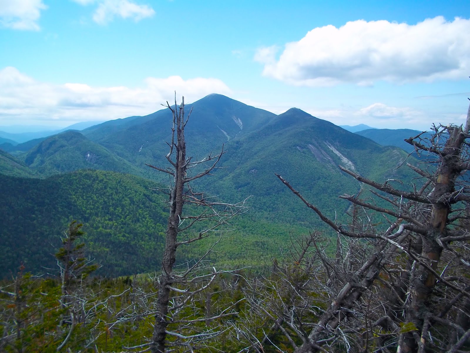
Great Range from First Brother.


We approached Big Slide via the Three Brothers trail. The Brothers are three smaller sub peaks on the mountain. The first two Brothers offer amazing views on their own and require some simple rock climbing to get over them. The trail goes around the shoulder of the Third Brother en route to the Summit of Big Slide.


Big Slide from the Brothers.


There aren't many water sources on this path. So, if you're hiking the Three Brothers trail out-and-back on a hot day - come prepared.


The Brothers trail is quite remarkable. As I mentioned, the views are outstanding and it's not an overly rigorous route... Whoever cut this trail definitely knew what they were doing!


Just below the Summit, there's a trail junction. Following the trail towards the Summit we hit an incredibly steep pitch with a series of ladders. Then, we reached an overlook next to Big Slide's Big Slide.

At the slide, I noticed a parhelion rainbow.
"They call those sun dogs," noted Jim, " Ya know, that might be a good trail name for you. "

The trail name was a reference to an old college nickname... I like it. I might keep "Sun Dog."

Once we passed the slide, it was an easy climb to the Summit.


Ladders.
Part of the "Big Slide."


On the way, a Quebecois woman complimented Kailee. People are usually surprised when they see her up around 4000' in the sky.

"She is very good!" The woman exclaimed in a thick French accent, "She is very strong!"

Moments after this, we were atop Big Slide admiring it's absolutely gorgeous view. Giant Mountain commands everything to the North-east, the Great Range puts on a show smack dab in front of you and the State's highest point Mount Marcy watches over everything from the South.


Great Range & Marcy from Big Slide's Summit.


We all agreed that this was one heck of a climb and Summit. I had heard there wasn't a summit marker on Big Slide. But, I found one hidden behind a pine tree. A classic Verplanck Colvin survey bolt. Still beautiful & shiny after 140 years.


We enjoyed lunch while Jim and I discussed how a very prominent slide on the side of Lower Wolf Jaw looked like a highway... More on this note in a future entry.

Kailee played with a hiker's dog, performed the floss dance & did some back-bends.

While dancing, she noticed a critter.

"Hey, a baby raccoon!" Kailee shouted, "Wait... That isn't a raccoon."

I stepped near her and saw it.

"Hey, Kailee, that's a marten," I said as the cutest creature ever created happily scurried away from the ledge.

The marten's red & brown coat was marvelous. Kailee became extra excited upon my confirmation of the adorable critter. She had wanted to see one since seeing an episode of Wild Kratts and learning that they are common around Noonmark Mountain when we hiked it.

This was an exceptional way to finish up our time on top of Big Slide.

Jim & I had pretty much agreed in advance (with room for changes in plans of descent) to take the Slide Brook Trail down the mountain and hike out of Johns Brook Valley on the Phelps Trail.

The three of us were in agreement afterwards that we took a good path down. We got to see more of the mountain by doing this and obtain a better perspective of Big Slide.

The Slide Brook Trail is pretty much a straight shot down the mountain. The parking attendant at the Garden parking lot had previously informed us that the trail crosses the brook a few times around 2/3rds of the way down.


This ended up being both fun and helpful... Kailee loved seeing that the next trail marker was a rock hop across the brook and I needed water.

I finished up the contents of my water pack about a half mile before we hit the stream. This was actually the first time that's happened to me on a hike. I usually have at least a little bit -if not more- leftover when I'm done...

Based off the map, the parking attendant's words, and the sound of rushing water... I was glad that I was in a position that I could filter water... And, that's what I did at a beautiful pool!

At the final stream crossing we hit a merger of a brook crossing and a very old slide.

"This is SICK!" Kailee shouted beyond enthusiasm "I LOVE Big Slide!"

"I would take a selfie right here," Jim commented as we walked down the old slide, "But, all of my friends would just think that I'm in a parking lot."

A very funny observation.

Soon enough, we reached the end of the Slide Brook Trail. At this junction, it was 3 miles back to the Garden... But we decided to tack on a half mile side trek to Johns Brook Lodge - a historic campsite run by the ADK Club.

This was another decision that we were glad to make. It was everyone's first trip to JBL and it was worth the jaunt.


The property is lovely. The top of Gothics steals your attention at the Lodge. But, there is plenty to explore and appreciate right there!

During our hike, we were told that JBL offers free lemonade... At this point in the day... Lemonade held a lot of appeal to me.

I sent Kailee into the Lodge to fetch three cups of lemonade. This was two-fold. Yes, I wanted the lemonade. I also thought it would be neat if she was the first out of our little crew to scope out the interior of the Lodge.

Kailee came out of JBL empty handed.

"The lemonade isn't free," She said, "It's 50 cents."

I gave her the money for three drinks. A few minutes later, Jim and I joined Kailee inside to get our drinks and check things out. The Lodge is very pretty & has that rustic North Country feel. We chatted with the caretaker for a bit as we finished up our drinks. Then, it was time to make the 3.5 mile walk back to the Garden.

About a 1.5 miles from the car, Kailee spotted something... It was moving really fast through the trees and kicking up leaves!

"Bear!?!?!"

This was no bear. It was a runaway boulder that came spiraling down the mountain and crashed into a large rock in the middle of the trail 40 feet in front of us!

We were fortunate to not be in it's way! However, we all agreed that it was pretty cool that we witnessed it.

The rock that crashed into the trail in front of us.


"It's too bad you weren't taping with your camera," Jim said, "You could've edited in some bowling alley noises."

Luckily, the rest of our walk out was uneventful. We were all glad to get back to the Garden. This ended up being our 6th High Peak and Jim's 11th! We said "Goodbye" to Jim and headed for home.

Later that night Kailee came up to me and said "My muscles in my arms are really strong from carrying my backpack all day!"

She must've been thinking about the compliment the Canadian had given her.

I squeezed her little pencil arms and laughed... And, continued to laugh about this scene for the next  two days.


 "Sun Dog" with the Sun Dog.


Tuesday, June 26, 2018

Cascade 6-6-2018

Summit Undies on Cascade!

Cascade has been making waves in the headlines a lot this past year. Due to parking concerns, the New York State DEC is currently planning on moving it's easily accessible trailhead from it's current location on Route 73 to Mount Van Hoevenberg which would add at least 3 miles to the hike.

Personally, I think the potential move is extreme and other alternatives should be considered such as painting lines in the parking lots, lowering the speed limit around the trailhead and operating a shuttle bus to transport hikers from an overflow lot at Van Hoevenberg to Cascade during busy Summer weekends.

But, I digress...


Such a busy parking lot on a Wednesday... NOT!

In anticipation of the proposed move, I decided to make an afternoon trip to Cascade after work. I had no plans of tagging Porter on this day. For a more complete review of Cascade and Porter click here.

I pulled up to the trailhead. There were five other cars in the lot. One of them was leaving... Real busy... Yeah right...

I enjoyed plenty of solitude on this hike. I only passed five other people who were descending as I ascended... So overcrowded... Yeah right...


I had the Summit to myself... It was really hot and muggy. I had neglected to pack my shorts. Since I had the place to myself, I kicked off my pants and hung out in my underwear for a bit until I cooled off.


Clouds over the Great Range and Big Slide just chilling out.


Clouds were rolling into the High Peaks. It was pretty cool. I ate a sandwich and relaxed for almost an hour before departing.


Here come the clouds!


I thoroughly enjoyed this hike and having the place to myself. Cascade has a pretty phenomenal summit.


If you're considering climbing Cascade, I suggest doing it soon and doing it on a weekday. If you hit it up on a Wednesday, it's pretty likely that you'll have this "overcrowded" gem to yourself.


Monday, June 11, 2018

Phelps 6-3-2018


Phelps Mountain - 4160'.
The 32nd tallest Adirondack High Peak.

Our trip to Phelps Mountain was a spirited hike which included a few notable firsts. Included among them: this was our first trip to the inner High Peaks zone. The four 4000' peaks that we previously tagged all sit on the outside perimeter. 


Kailee was excited about this trek and instinct told her that we'd be climbing a High Peak, "Because the weatherman on TV said that Sunday would be perfect." 

I figured that parking at the Adirondack Loj would be a mess and concluded that we should start our hike at South Meadows and approach the wilderness via the Marcy Dam Truck Trail. This path would add some slight mileage compared to starting at the Loj. However, I was aware from researching topographic maps that the Truck Trail is mostly flat and the extra distance wouldn't be a problem.

The truck trail passes over a few pretty streams and it got us to Marcy Dam fairly quickly.
This was the first time that either of us had visited the dam. New York DEC is currently in the process of removing the dam and allowing the area return to it's natural form. It was cool seeing what's left of it and the view of Wright Peak and Colden was stunning.


Wright Peak from Marcy Dam.

After a quick break, we signed a second register and began hiking the Mount Marcy trail. The trail to Phelps splits off of the Marcy Trail and crosses another beautiful stream. After this point the climb up Phelps began in earnest.


The Phelps Mountain trail wasn't very challenging and the incline was never to demanding. Kailee had no issues with it. I thought the trail seemed sort of beat and that a re-route in the near future might be a good thing.

A little over halfway up, we took another break and munched on some snacks.

There was one little scramble as we neared the top then we continued along the path through the pines before popping out on the Summit shelf. This last stretch of trail offered some spectacular views of the McIntyre Range & Colden.


The McIntyre Range viewed en route to the Summit of
Phelps.
The Summit itself offered an expansive view from Big Slide to the Great Range to the McIntyre's. A number of the biggest mountains (Giant, Gothics, Dix & Marcy) had their heads in the clouds for the duration of our visit.


Colden.

A number of other adults in their 20s & 30s soon arrived at the Summit and we did a bit of socializing and Kailee was delighted to play with a dog that accompanied one of them. Everyone was in a great mood and smiles were abound.


Summit Back-bend!
Tabletop in the background.


After an enjoyable time at the Summit, it was time to head back. We took a short break when we reached the stream crossing and I let Kailee try out our water filter. We then made our way back to Marcy Dam and took another little break. Kailee dunked her hat in the stream to cool off and we took in a final view of Wright and Colden before departing for the car.

At this point, I decided to carry both of our backpacks so Kailee could have an easy walk back.

We had a really great time on this trek. Phelps is really nice & it was awesome to finally visit Marcy Dam. Whether you're a peakbagger or casual hiker, put Phelps on your bucketlist and wear a smile to the Summit!


Saturday, June 9, 2018

Tupper Lake Triad + Panther Mountain (5-28-2018)


Goodman Mountain. "One!"

Kailee has hit so many summits since last August that she's been long overdue for a hiking badge. With Memorial Day weekend coming up, it seemed like a good time to leave the popular trails to the tourists and work on getting the girl her first hiking challenge badge.

So we set our sights on the Tupper Lake Triad. The challenge consists of climbing three smaller peaks (Goodman, Coney & Mount Arab) surrounding the Tupper Lake area.

I had planned for us to start with the mountain furthest away from us (Coney) and work our way back home. However, things played out a little differently. I really just wanted to get out of the car and start hiking after 90 minutes of driving. So, we pulled into the lot for Goodman (even though it's only a mile away from Coney) and we began our challenge there.


Goodman Mountain

The weather was beautiful as we strapped on our gear. We checked out the information board which provides details on the mountain's namesake Andrew Goodman.


Andrew's family used to vacation in the area every year. When he was 20 years old, he became involved in political activism and joined the "Freedom Summer" movement in 1964. The goal of the movement was to register black voters in Mississippi.

Sadly, Andrew and his two companions caught the attention of a crooked Sheriff in Philadelphia, Mississippi. The three young activists were then brutally murdered by the Sheriff and the Ku Klux Klan. Their murders were a key factor in Lyndon B. Johnson signing the Voting Rights Act of 1965.

Goodman Mountain is a pleasant little ramble. The trail follows an old forest road (wheelchair accessible) for the first mile. It then hooks left and works it's way up the mountain. It's a pretty easy climb with no scrambling or obstacles to overcome.

Wheelchair Accessible Trail at Goodman.

The view from the Summit was cute and offered us a look at our next target: Coney.

A view from Goodman's Summit.


Goodman's trail basically makes a lowercase "j" shape. From the Summit, I determined that we could bushwhack, shave off a little mileage and make a lowercase "b" shape track.


And, that's what we did! We descended into the woods and a short time later, we linked back up with the forest road and took off.


Coney Mountain
"Two!"


It only took a minute or two to drive from Goodman to Coney.

The trail starts near some runoff and hooks around the mountain to the Summit.

It was a nice easy walk despite the weather getting warmer and muggy.


We reached the Summit fairly quickly. Coney is a smaller mountain -but- it should not be overlooked.
It offers a full 360° view. The other two triad mountains (Arab & Goodman) are visible as well as the Seward and Santanoni ranges.
Views in every direction at Coney.

Coney was by far my favorite peak of the Triad.

When we got back to the parking lot, it was time to drive around Tupper Lake for our next target.


Mt. Arab


"Three!"

Perhaps the "easiest" of the Triad, Arab is a mountain that's quite different than others in the Adirondacks. It has a number of stairs, boardwalks and a bench at it's tiny overlook. Arab also has a firetower and an observer's cabin.

A boardwalk.

We ran into the steward who was descending as we neared the Summit. Kailee thought his two large dogs looked like bears.

Overlook and bench at Arab.

We enjoyed lunch on the cabin's porch. After our meal, I sent Kailee up the tower to take some pictures while I grabbed something out of my bag.

While she was in the tower, I pulled out a Tupper Lake Triad logo that I had printed off. I climbed the tower to give it to her and congratulate her on her accomplishment.


Tupper Lake Triad completed!

Arab's Observer's cabin.
The view from the tower was pleasant. Kailee said it was her favorite of the Triad.
The only downside to Arab on this day was bloodthirsty gnats. They would not stop attacking my elbows & leaving behind painful slash-shaped bite marks.

The Tupper Lake Triad was a lot of fun. Kailee was very excited to receive her badge in the mail. The Triad is a great challenge for kids, beginners and experienced hikers. We highly recommend it!


Panther Mountain


On our way home I decided to stop for one more quick hike at Panther Mountain (not to be confused with the High Peak of the same name) on Route 3.

Panther gained some attention recently as it was used as a substitute for Ampersand in the Saranac Lake 6er Relay Race last Fall.


Ampersand from Panther.

Because of this distinction, I've wanted to check out the "7th" 6er for a little while. It's only a half mile to the Summit and not a hike that I would go out of my way for... But, since we were in the area it became number four for the day.

The trail is pretty steep but it switchbacks most of the way up.


Panther's Summit.

It took us only 20 minutes to reach the top. The Summit offers a great view of Ampersand Mountain and Panther Pond. It was a nice quick hike to finish the day off and I'm glad we made the quick stop.


Friday, June 1, 2018

Lyon Mountain 5-20-2018


Lyon Mountain is the highest point in Clinton County. At 3830' it falls just shy of being a High Peak but due to it's size and isolation it ranks up as the 8th most prominent peak in NY.

Sean really talked it up during our hikes of St. Regis & Scarface last year and it's been on the bucketlist since then.

Lyon is a familiar landmark, I look at it every day on the drive to work. So, I was looking forward to checking it off the list. Kailee was excited about this one as well.

We got to the parking lot around 1:30PM... Our car was the only one from NY. The rest were all from Quebec.


The trail register is near a nice little runoff. And, much of the trail itself was runoff for the day.

That being said, Lyon has a relatively new trail and it's all switchbacks! So many of our trails in the Adirondacks are usually straight shots that can wear you down. This was a changeup that was welcomed with open arms.

The hike up was gentle. Armies of trilliums surrounded the trail.


Recently, I've been listening to a hiking podcast and one of the hosts was startled on the trail by his friend who shouted at him "The British are coming! The British are coming!"

Kailee thought this was funny and would yell out "The British are coming!" whenever she heard hikers descending towards us and we'd laugh.

One man gave us a stern look... Too bad bro.

Hazy day.


Around 3600' we hit trail ice. I put on my spikes and we navigated our way to the top. It was a gray day... We summited into a cloud.


 It happens.


Even the tower wouldn't provide any views
on this day.


We ate lunch behind a big rock before making our descent.

Rather than dealing with the ice again, we bushwhacked for a bit.

It was an easy walk out once we linked back up with the trail. Of course, the sky began to clear as we descended... Oh well.


Sure... Now, it clears up...

This was a fun hike & I can't emphasize how much I loved the relief of being on a switchback trail!
Lyon is a big mountain and a 7 mile trek but pretty much anyone can do it.


Lyon Mountain from across Chazy Lake.